September 12, 2024 by David McGuire
On a clear San Francisco day looking west,
– you might see a smudge of jagged peaks can be glimpsed at the edge of the horizon. This rugged archipelago of wind and wave-worn rocks form the Farallon Island chain. Located 26 miles from the Golden Gate, the Farallones are composed of Southeast Farallon Island (SEFI, the tallest), Middle Rock, the Island of St James to the North, and Noon Day rock. This group of islands host a history of shipwreck, murder and the birthplace of millions of seabirds and seals. Known as the Islands of the Dead by the coastal native Americans, whom left no evidence of visitation, but the islands have a rich and sometimes tragic history of human occupation.
It is believed that the first Europeans to see these islands were on the expedition lead by Juan Cabrillo in 1542, who is said to have reached Point Reyes, just 20 miles north of the islands. However, no record exists of the Cabrillo expedition’s actual sighting of these islands. The first credited visit was in 1579 when Sir Francis Drake landed to collect seals and seabird eggs. An English sanctioned pirate sent to pillage gold from the Spanish Galleons, Drake is credited for charting the later named Drakes Bay (it is debated), and gave the islands the name Isles of St James. 39 years later, the Spanish explorer Sebastián Vizcaíno visited and charted the islands relative to Pt. Reyes in 1603. Aboard was Friar Antonio de la Ascensión who gave them their name, Los Farallones in Spanish (meaning sea pillar, or sea stacks). For nearly 200 years early mariners, including scores of Spanish Galleons heading south to Mexico, missed the San Francisco Bay opening. Shrouded in fog, and surrounded by hazardous rocks and shallows, the Bay was not discovered until 1769 by members of the Don Gaspar de Portolá Expedition, when an exploration party sighted the Bay from Mount Sweeny near the town of Pacifica.
The years following the discovery of the Farallones saw an increase in the maritime fur trade. Yankee and Russian sealers exploited the rocky promontories and islands where seals hauled out. During the early 1800s, Russian and Aleutian seal hunters established a camp on SEFI where they harvested hundreds of thousands of seals for their fur and meat. It was estimated that around 1,500 Northern fur seals were killed annually over the first decade. Elephant seals were also killed for their blubber to use as oil and seabirds and eggs were harvested for food.

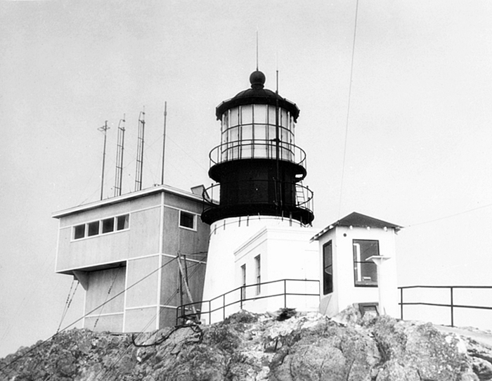
“CENTER OF ACTIVITY–Above is the center of activity on the islands, the big light, and to the left the radar station, which controlled coast radar.” Dec 5, 1945 Source San Francisco History Center, San Francisco Public Library.
By 1820 the fur seal population was completely killed off and extirpated from the islands, and it was not until 1996 that the northern fur seal began to recolonize the islands. The Northern Elephant Seal, Stellar’s Sea Lion and California Sea Lion were also reduced significantly, and took decades to recover. It is believed that the Guadalupe Fur seal and Southern sea otters were also completely extirpated. and These species have not yet recolonized the region, although the Mexican dwelling Guadalupe Fur Seal (named after the other white shark hot spot south of the border) has been observed visiting SEFI.

Beginning in 1853, a lighthouse was constructed on the highest point of SEFI, named Tower Hill, at 357 feet. The original hill-top tower was too small to house the fine first-order Fresnel lens and had to be torn down and rebuilt on a nearby site that could accommodate the lens on a larger tower. In 1855, Farallon Island Lighthouse became the sixth lighthouse to be activated on the West Coast. To help the builders haul the bricks and heavy materials up the steep hill, a mule named Jack was brought to the island. Once his construction labors were done, Jack remained on the island for eighteen years to help carry oil and supplies up to the lighthouse, dragging supplies along a small gauge rail constructed for the purpose.
As the city grew, the seabird colonies came under severe threat as eggs were collected by the thousands to supply the new San Francisco market. The Gold Rush created a sudden new population in San Francisco without local farms or infrastructure and the Farallons became a source of eggs from common murres to sell to hungry miners. The harvesters collected murre eggs by the hundreds of thousands, and a rivalry for the resource developed. A group of armed harvesters formed the Pacific Egg Company, claiming the island and the eggs for themselves. Some lighthouse keepers also participated in egg harvesting, with one lighthouse keeper claiming ownership to the rights over harvesters that visited from San Francisco. The trade, which in its peak yielding 500,000 eggs a month, was an increasing source of conflict between the egg-collecting companies and the lighthouse keepers. This conflict turned violent in a confrontation between the rivals in 1863 in what was called the Egg War. Twenty seven armed men landed and the shootout left one dead on each side and two wounded. Finally brought to the US government’s attention in Washington DC, the government claimed ownership of the island, and evicted the egg company in 1881, making egg collecting illegal.
In 1878, a Victorian duplex was built to house the lightkeepers and their families, and an another identical to the first was added in 1880. These two structures remain in service, inhabited by field mice and biologists from the US Fish and Wildife Service and the non-profit Point Blue.
In the early 1900s the US Government took over the islands in earnest. The collecting of eggs along with the threat of oil spills from San Francisco’s shipping lanes, prompted President Theodore Roosevelt to sign Executive Order No. 1043 in 1909, creating the Farallon Reservation to protect the chain’s northern islands. This was expanded to the other islands in 1969 when it became a national wildlife refuge.
Between 1902 and 1913, the U.S. Weather Bureau built and maintained a weather station on SEFI, connected by cable to the mainland at Marin until washed away in a storm. Weather buildings constructed on the west end in Fisherman’s cove suffered the same fate, in one case with a weatherman inside. Later, the National Weather Service provided weather observations from the lighthouse on its local radio station.
In approximately 1905, the U.S. Navy installed and commissioned a Radio Direction Finder (RDF) Station on the Southeast Farallon Islands. Nine Navy personnel were stationed on the island to support the radio station until after World War I. After the war, personnel were cut back to four or five people. Several buildings and other structures were constructed to support the Navy’s mission on the island, leaving many behind. These included two compass houses, a powerhouse, officers’ quarters and dormitories, several sheds, and equipment associated with a saltwater distillation facility. Navy personnel were stationed on the island up until the late 1930s manning a secret radar outpost during the war.

In 1939, the Coast Guard took over the lighthouse and operation of the fog signal. During World War II the US Navy reoccupied the island and the population on the island grew to over seventy. The Coast Guard took over running the lighthouse, and together the two branches created the largest population of 78 people on the island during World War II. The lighthouse and foghorn served the critical role of preventing incoming ships from colliding with the rocky islands, yet the fog and weather took their toll on several ships over the years. Following the war, the Navy left the island to the lighthouse keepers and their families. In 1950, census taker Helen Mabbott traveled to Farallon Island where she earned $2.31 for counting the island’s 30 residents – seven cents a head and seven cents for each of the island’s 3 houses.
In the late 60s, scientists with US Fish and Wildlife and the Point Reyes Bird Observatory took their place on the island to help monitor the wildlife. Farallon Island Lighthouse was automated on September 1, 1972, and after 3 months the Coast Guard personnel left the islands to the seabirds, the seals, and the scientists.

Most of the research focuses on the abundant bird life that use the remote islands to nest, fledge their chicks and feed in the rich waters. Several endemic species live on the island and many rare and endangered species use the rocky outcrops to nest, like the Ashey Storm Petrel. Several blinds have been placed on the island for biologists to observe and record nests, fledged chick success and pinniped populations and mating. A daily lookout is held from the old lighthouse tower collecting data on whales and white shark predation events as well as human behavior eg boats flushing seabirds or fishing illegally in the Marine Protected Area near the island.
Protected Status
The collecting of eggs along with the threat of oil spills from San Francisco’s shipping lanes, prompted President Theodore Roosevelt to sign Executive Order No. 1043 in 1909, creating the Farallon Reservation to protect the chain’s northern islands. This was expanded to the other islands in 1969 when it became a national wildlife refuge.
In 1981, Congress designated the Gulf of the Farallones National Marine Sanctuary, which spanned 1,279 square miles (3,313 square kilometers; 966 square nautical miles) of water surrounding the islands. This sanctuary protected open ocean, nearshore tidal flats, rocky intertidal areas, estuarine wetlands, subtidal reefs, and coastal beaches within its boundaries. In 2015, the sanctuary was enlarged north and west of the original boundary, partially surrounding Cordell Bank National Marine Sanctuary, to encompass 3,295 square miles (8,534 square kilometers; 2,488 square nautical miles), and the name was changed to Greater Farallones National Marine Sanctuary.
The islands are famous for the white shark aggregation that patrols the islands to prey on pinnipeds (seals and sea lions). Dramatically reduced from pollution, loss of prey and direct fishing, the white shark population began to recover since protection began in 1993. Biologists on the island began to document an increase in predation events near SEFI. Pioneer scientists Dr. Peter Pyle and Scot Anderson, later joined by Dr Peter Klimley began deploying decos and launching a boat to investigate and document white sharks using photography. In the 1990s, white shark cage diving increased in popularity creating friction between the scientists and tour operators. In 2005, a journalist Susan Casey obsessed with white sharks, published a book called The Devil’s Teeth. Casey, then a journalist for Sports Illustrated, pitched an article that required permission from the Department of Fish and Wildlife. During the second year, she received permission to write but not come onto the island. The writer befriended biologists Peter Pyle and Scot Anderson, then researchers on the island studying the seabirds and the white shark population. These scientists had been documenting predation events and photo-Identifying individuals, from shore and from a small boat. Casey tells a compelling and harrowing tale of white sharks and the extreme conditions on the island. The kiss -and -tell recounting of Casey’s visit ashore, and the loss of a loaned sailboat during a storm she was to be quartered on, resulted in the dismissal of the two scientists and a hiatus in the white shark research.

The white shark research resumed with Stanford University and the Monterey Aquarium, who have tagged and identified over 100 sharks at SEFI, tracking several via satellite tags across the Pacific 2000 miles and back. During Covid, the Monterey Bay Aquarium shut down the white shark research project and the Stanford program took a recess at the islands. Studies at Ano Nuevo, at Dillon Beach and last year at SEFI resumed, led by the Block Lab at Stanford’s Hopkins Marine Laboratory, University of California Santa Cruz, Oregon State University and Montana State University.
Also protected from fishing and harassment under federal law, the US Fish and Wildlife, with the National Marine Sanctuary suspended all non-research activities involving white sharks until a formal review was held. The White Shark Stewardship program was implemented requiring any non scientific operations to apply for a permit approved by NOAA’s Greater Farallones National Marine Sanctuary. This permit restricts harassing white sharks, chumming or other attraction other than use of a decoy, and trained naturalists are required to be onboard.
Fishermen are prohibited from fishing the waters near SEFI and the North Farallones under the California Marine Life Protection Act. The Golden Gate Marine Protected Area Collaborative is a local network charged with educating and facilitating compliance, and provides a brochure to fishermen with maps showing where fishing is allowed. Today, only biologists, maintenance staff and a few volunteers from the Farallon Patrol are allowed to go onto the island. However, the public can join us crossing the Gulf circumnavigating the island via boat on our Sanctuary education adventures with Shark Stewards, taking care to avoid coming within the 1000 foot special closures established to protect nesting seabirds and the seals on the island.
References
- Annual Report of the Lighthouse Board, various years.
- The Farallones, Sentinel Publications.
- The Farallon Islands, Sentinels of The Golden Gate, Peter White, 1995.
- The Devil’s Teeth, Susan Casey, 2005.
- Lighthouses of the Pacific, Jim Gibbs, 1986.
Additional Readings
Bean, Lowell John (editor), 1994. The Ohlone Past and Present: Native Americans of the San Francisco Bay Region. Ballena Press, Novato, CA.
Chartkoff , Joseph L., and Kerry K. 1984. The Archaeology of California. Stanford University Press, Stanford, California.
Colley, Charles C.1970. “The Missionization of the Coast Miwok Indians of California”. California Historical Society Quarterly, 49(2): 143-162.
Cook, Chartkoff, Joseph Sherburne F. 1976. The Conflict Between the California Indian and White Civilization. University of California Press, Berkeley, California.
Heizer, R.F. and M.A. Whipple (contributers and editors). 1971. The California Indians: A Source Book. University of California Press, Berkeley, California.
Kroeber, Alfred L., 1925. Handbook of the Indians of California. Bureau of Ethnology, Bulletin 78, Washington D.C.
Margolin, Malcolm, 1978. The Ohlone Way: Indian Life in the San Francisco and Monterey Bay Areas. Heyday Books, Berkeley, CA.
Milliken, Randall, 1995. A Time of Little Choice: The Disintegration of Tribal Culture in the San Francisco Bay Area 1769-1810. Ballena Press, Novato, CA.
Moratto, Michael J. 1984. California Archaeology. Academic Press, San Francisco, California.
Peterson, B.J. (editor). 1976. Dawn of the World: Coast Miwok Myths. Marin Museum Society, Impressions Printing, Woodacre, California. Original: Myths and Weird Tales Told by the Mewan Indians of California, Arthur H. Clarke Company, Cleveland, Ohio, 1910.
Yamane, Linda (editor). 2002. A Gathering of Voices; The Native People of the Central California Coast. Santa Cruz County History Journal, Issue 5; published by the Museum of Art & History, Santa Cruz, California.